adsense analytic

Showing posts with label Land Surveying. Show all posts

Monday, July 23, 2018

Setting out survey process – Definition and various benefits

Setting survey process is applied to set out the exact position of a projected structure inside the legal boundaries of a plot of land.

The objective of setting out is to set out perfect position & levels of building lines and road alignments for a projected structure as per construction plans by applying different techniques and instruments.

This type of survey is very vital while going to set up any type of construction work.

Generally, a set-out survey comprises of the process for transforming a building design onto the land itself in order that the builders can abide by the process throughout construction. Throughout the process, major points are set up and markers are applied for the progression of the building process and maintain perfectness.

For large scale projects like high rise buildings and developments, multiple set-out surveys are required as the construction advances. This type of survey is mainly undertaken for the earthworks, roads, car parks, sewerage, water and the actual buildings themselves.

Methods of Setting Out Survey


1. Setting out buildings by coordinates
2. Setting out with theodolite and level
3. Examining verticality
4. Setting out and alignment in steel framed buildings
5. Alignment and verticality in form work
6. Control and computation for route surveying
Setting Out Building by Coordinates
A building is set out by adopting referencing from an already established baseline. An asymmetrical building or a building with complicated geometry can also be established by applying the equivalent process. For each corner of the building, a grid line is set up from the baseline.
Examine Verticality - The verticality of points in a building is examined with the following surveying instruments:
1. Plumb Bob (For buildings less than 20m in height)
2. Optical Plummet (A transparent plastic sheet is used as a target for checking verticality of tall buildings)
3. Theodolite
Setting out Survey works also contains the following :-
Calculations and setting out Methods for:
1. Simple Circular Curves
2. Compound Curves
3. Reverse curves
4. Transition curves
5. Vertical curves
To get more details, go through the following video tutorial
Video Source: Finchley College

~~~~~~~~~~~~~~~~~~~~~~~~
Published By
Rajib Dey
www.constructioncost.co
~~~~~~~~~~~~~~~~~~~~~~~~

Tuesday, June 26, 2018

Brief overview of rise and fall table in land surveying

This construction video tutorial is very useful for land surveyor. The tutorial sheds light on the rise and fall table in land surveying. Get some useful tricks to resolve the rise and fall table.

Rise and fall method is applied to resolve the levelling to detect the variation in elevation and elevation of points..


By resolving this table, it is possible to work out the reduced level of each point captured at staff rod with leveling machine. In order to work out the reduced level of an individual point, it is necessary to compute the rise and fall of points. After that, for reduced level, the following formula is applied :-

new R.L = old R.L – Fall
new R.L = old R.L + Rise


The table contains various heads like number, B.S (back sight), I.S (inter sight), F.S (fore sight), Rise, Fall, R.L (reduced level) and remarks.

B.S - Back sight (BS) is the abbreviation for "back sight reading". It means the first staff reading captured by the surveyor as soon as the levelling instrument is arranged and levelled. B.S is normally captured on the point of known reduced level as on the benchmark or a change point. The normally applied datum is mean sea level.

Fore sight (FS) is the abbreviation for "fore sight reading". It means the last staff reading captured prior to modify the instrument to the other position. It refers to the staff reading captured on point whose RL is to be ascertained. This sight is treated as negative and assumed from Height of Instrument to find out RL of the point.

Reduced Level (RL) in surveying stands for equating elevations of survey points relating to a common assumed datum. It refers to a vertical distance among survey point and selected datum plane. Therefore, it is taken as the base elevation that is applied as reference to consider heights or depths of other important places.

To get more detailed information, watch the following video tutorial.


~~~~~~~~~~~~~~~~~~~~~~~~
Published By
Rajib Dey
www.constructioncost.co
~~~~~~~~~~~~~~~~~~~~~~~~

Monday, June 25, 2018

Details of chain surveying - Benefits and Drawbacks

Chain surveying is the sort of surveying in which only linear measurements are selected in the jobsite.

This type of surveying is undertaken for surveys of small span to specify the boundaries of plot of land to detect the existing features on them.

Chain surveying is the simplest form of survey in which surveying area is segregated into a number of triangles and the sides of different triangles are calculated directly in the field through a chain or a tape and no angular measurements are chosen. Chain is most recommended for initial survey process.

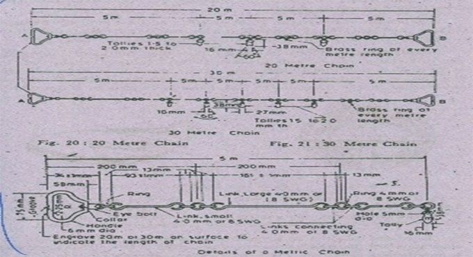
Chains stands for the measuring devices which are applied in surveying. These are produced with the 100 links of 4mm galvanized mild steel wire. These links are attached with 3 circular or oval wire rings. These rings make the chains flexible.

The chain comprised of several small segments to manage or study the measurements.

At the ends chain contains brass handle with swivel joint to simplify the process for rolling or unrolling the chain devoid of twisting and knots.

At each 10th link is arranged with a total of one teeth, 20th link with a total of two teeth and so on till 40th link. With these arrangements, the reading of measurements can be taken efficiently.

At the center of the chain, there is a circular talley used for easy reading.

Chain surveying devices: 1. Chain, 2. Tape, 3. Arrows, 4. Ranging Rods, 5. Offset Staff, 6. Optical Square

Types of Chains utilized in Surveying - The chains are categorized as follow depending on the length of the chain:

Metric chains, Steel band or Band chain, Gunter’s chain or surveyor’s chain, Engineer’s chain, Revenue chain

Benefits of chains :-

a. The chains can be read easily and instantly
b. They can resist wear and tear
c. They can be repaired in the jobsite without any difficulty

d. There is no requirement to adjust measuring tape
e. This type of survey work is very effective for a small plain ground.
f. It needs simple instruments.
g. Plotting of maps is very simple and trouble-free.


Drawbacks of chain:

a. They are heavy and take long time to open or fold.
b. They turn to be longer or shorter because of repeated use.
c. If measurement is done in suspension the chain sags greatly.
d. Error in measurement may occur because of temperature, sagging and marking.
e. Requires more manpower to complete the layout.


This type of surveying is recommended for undulation land where chaining operation is tiresome and prone to errors. This method should not be undertaken for a crowded city containing a huge numbers of buildings and obstacles since it cannot be separated into well-conditioned triangles. As for instance route surveying.

For conducting the survey work of a road, irrigation canal, railways, water and sewer lines, tunneling etc., this method is not suitable at all.

Details of chain surveying - Benefits and Drawbacks

Read more

~~~~~~~~~~~~~~~~~~~~~~~~
Published By
Rajib Dey
www.constructioncost.co
~~~~~~~~~~~~~~~~~~~~~~~~

Wednesday, June 6, 2018

Get some useful tips to conduct your leveling survey at home

While going to layout something for road, bridge, dam or pipe line, land surveying plays an important role. Surveying is done to find out the legal boundaries among the parcels of property, the position of current infrastructure, the topography as well as slopes of the land.

Traditional measurement tools like a tape measure and protractor are not suitable for accomplishing large civil structures and public works projects.

In this construction video tutorial, Mr. Grady shows some useful tips which will help you to conduct your own topographic or leveling survey at home with fairly elementary and cost-effective tools. You don’t require any knowledge with sines, cosines, or tangents.

To learn the complete process, go through the following video tutorial.

Video Source: Practical Engineering

~~~~~~~~~~~~~~~~~~~~~~~~
Published By
Rajib Dey
www.constructioncost.co
~~~~~~~~~~~~~~~~~~~~~~~~