adsense analytic

Showing posts with label Instruments. Show all posts

Friday, February 28, 2020

Some important terminologies in surveying and leveling

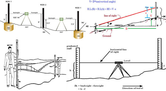
Leveling stands for the method of finding out the relative elevations of several objects or points on the earth's surface. It is performed by picking up measurements in the vertical plane. A leveling instrument known as ?Level? and ?Staff? is appointed for this purpose along with other equipments.
Given below, some vital terms in Surveying and Leveling :-
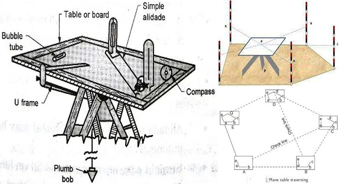
Level Surface: It refers to a surface that is normal to the direction of gravity at all points as stated by a plumb line. As for instance, the surface of a still lake can be a level surface.
Since the earth is an oblique spheroid, a level surface should not belong to a plane but should be a cursed one. The distance of each point on a level surface is equal from the center of the earth.
Level Line: A level line belongs to a line that is laid on a level surface. It is normal to the plumb line at all points.
Horizontal Plane: A horizontal plane through a point refers to a plane peripheral to the level surface at the point. It is normal to the direction of gravity at that point.
Horizontal Line: A line that remains at a 90 degree angle to the plumb line and tangent to a level surface is called a horizontal line.
Vertical Plane: A vertical plane belongs to any plane with a vertical line. A vertical line at any point stands for a line normal to the level surface at that point.
A plumb line is an instance of a vertical line.
Datum Surface: A datum or datum surface is the level of a point or the surface relating to which levels of other points or planes are measured.
Elevation of a Point: Elevation of a point is the vertical distance above or below the datum. This is usually called the reduced level (R.L) of the point. This may be positive or negative accordingly as the point is above or below the datum.
Line of Collimation: The line of collimation or the line of sight stands for the line that connects the junction of cross-hairs to the optical center of the object glass and its continuation.
Some important terminologies in surveying and leveling
~~~~~~~~~~~~~~~~~~~~~~~~~~
Published By
Rajib Dey
www.constructioncost.co
~~~~~~~~~~~~~~~~~~~~~~~~~~

Wednesday, February 12, 2020

What is Plane Table Surveying

Plane Table Surveying is used in ad-hoc surveying and designing situations. In this, survey fieldwork and plotting work is done simultaneously. Therefore, there is no need for office work. This is best adapted to situations where high precision is not required. Thereby, it is greatly useful for small-scale mapping operations.
Instruments used in Plane Table Surveying - The Plane Table survey method uses very simple instruments. These are available everywhere.
1. Drawing Board: It is a board made of seasoned wood. They are available in many sizes. Generally, the field work is done in 40 cm by 30 cm boards. They also use the 75 cm by 60 cm boards, for larger work. In the field, a tripod is placed under the board with a ball socket in it. This enables the surveyor to draw on the board from any angle.
2. Alidade: An alidade is basically a ruler with a telescope. This is used on the drawing board to draw lines and rays according to the field. The alidade may also have a spirit level on it.
3. Compass: A tough compass is used to find the magnetic meridian of the place. Generally, the compass used in survey work also has two bubble tubes at right angles to each other.
4. Plumbing Fork: It is a rod with a plumbob attached to one end. This is used to ensure that other equipment is aligned perfectly vertically, when needed.
5. Spirit Level: It is a tube of liquid with a bubble inside it. The tube is slightly bulging in the middle. This lets the bubble stay in the middle of the tube when the level is perfectly horizontal. This is used to make sure the drawing board, or other equipment are placed horizontally.
6. Waterproof cover: A waterproof cover is used to cover up the paper on the drawing board from rain or other splashes and dust. This is generally made of soft polythene.
What is Plane Table Surveying
~~~~~~~~~~~~~~~~~~~~~~~~~~
Published By
Rajib Dey
www.constructioncost.co
~~~~~~~~~~~~~~~~~~~~~~~~~~